-

This GPR system is designed to determine the depth and position of utilities such as pipes, cables, reservoirs and drainage systems in a variety of soils at different depths. The GeoCart 2D software allows its user to see all information displayed in Google Earth.
$1,000.00 Add to Quote -

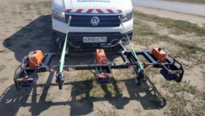
The OKO-2 GPR Road Set is designed for non-destructive inspection and analysis of the road structure. The device uses special horn antennae (400-2500MHz) located above ground level and fixed to a vehicle by an antenna bracket. The road complex offers users the single-channel and multi-channel solutions for high resolution surveys at speed up to 80 km/h.
$1,000.00 Add to Quote -

Construction Scan 1700 is a portable all-in-one GPR solution designed to automatically determine the location of defects in a wide variety of wooden, brick and reinforced concrete structures, at a depth of 1 m.
$1,000.00 Add to Quote -
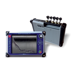
The OKO-3 GPR is a portable lightweight low-cost system designed for non-destructive environmental monitoring. The OKO-3 GPR includes a control processing unit and antennae. All antennae are interchangeable and meet the needs of a broad range of applications.
$1,000.00 Add to Quote -
Ground Penetrating Radar OKO‐3 is a portable, lightweight and low-cost system designed for non‐destructive environmental monitoring.
$1,000.00 Add to Quote -

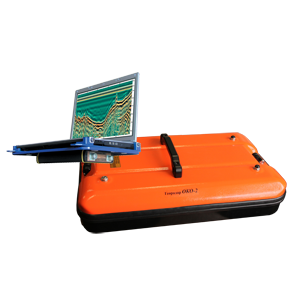
The integrated multi‐frequency GPR OKO‐2 is designed for automated location of objects at different depths, simultaneously and in real time. This GPR combines a control unit and two antennas with the different frequencies 150 and 400 MHz. The depth of sounding 12 and 5 meter, resolution 0,35 and 0,15 meter.
$1,000.00 Add to Quote -

Analysis-7 software complex. The Asphalt module is one of the newest developments. It is intended primarily for working with data obtained using the OKO-3 GPR. The latest version of the software implements the following features: automatic processing and interpretation of radargrams, analysis of the thickness of structural layers, moisture and slope. Automatic generation of reports is also available.
$1,000.00 Add to Quote -
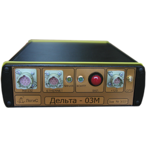
The Delta Seismic Recorder is designed to detect seismic signals from external (natural and artificial) seismic vibrations. This is a fixed seismic station with the possibility of data logging to a removable large‐capacity flash drive, and data transmission to a PC for real‐time analysis and recording.
$1,000.00 Add to Quote