
GEOSCAN-32-demo-fo-Windows-VISTA
GeoScan32
Geoscan 32 is designed to control the ground penetration radar (GPR) system, as well as for further processing and visualisation of the data obtained in the process of scanning.
Features
- Obtaining GPR data using the OKO-3 GPR in continuous mode, arrow mode (using odometer) and step-by-step mode
- Data visualisation during the survey
- Interactive determination of layer velocities and local objects occurrence depths
- Layer-by-layer processing
- Area survey data processing
- Terrain correction
- Trace editing
RadExProPlus
RadExPro Plus is a specially designed software for comprehensive processing and interpretation of near-surface on-shore and off-shore seismic, VSP and GPR data under Windows 9x/Me/2000/XP/Vista.
Features:
- Reflection data processing and interpretation
- Field quality control (QC) of 2D/3D seismic data
- Refraction seismic data processing and interpretation
- VSP data processing
- GPR data processing and interpretation
Analysis
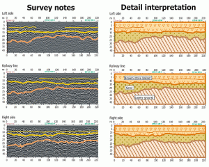
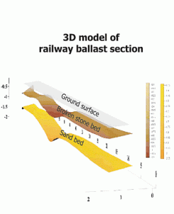
Used for automatic processing of GPR data, the module “Analysis” allows for the easy viewing of two- or three-dimensional images of ballast at any point in the survey (after the detection of structural layers).
ITS APPLICATIONS INCLUDE:
data visualisation during the survey;
processing in real time;
automation of GPR data processing;
data saving in an easily compatible format with professional geophysical programs.
RadExPro Plus™ runs on low-cost Windows-driven PCs and workstations. It doesn’t take much effort to install the software on a laptop. After that, this full-blown system for processing, interpretation and quality control of seismic data can be safely used on board.
Advantages:
- Convenient and easy data input/output allows loading of seismic and GPR data recorded in almost any format either from disk or tape
- User-friendly graphical interface enables creation of sophisticated processing flows for batch processing of seismic and GPR data
- Exhaustive set of efficient processing and QC procedures
- Set of fast interactive tools for seismic and GPR data visualisation and analysis
- Handy interpretation facilities: horizon picking, seismic sequence attribute analysis, interactive map, well-log data visualisation
- Flexible trace header management, including mathematical operations with header fields and much more
- Special tools for visualisation and analysis of header field values
- Powerful and fficient database that allows storing of seismic data, processing flows, well data, picks, velocity data, grids, etc
Open scalable architecture – in case of missing a specific module, users can build it themselves and integrate it into the package. (Programmers working in MS Visual C++ will be provided with special the User Application Wizard).
- High accuracy of GPR data
- Compatible with all antennae
- Removable rechargeable 12 V batteries
- Rugged, weather resistant housing
- GPS integration
- Several languages option (Russian, English, Chinese)
- Synchronisation of GPR sounding and video recording
- Horn antennae which can be installed on a vehicle and a railway car (speed up to 80 km/h)
- Advanced multi-channel multi-frequency system
- Technical support and assistance
- After sales service
- Free training
- One-year warranty
- CE certificate
The OKO-3 GPR is a portable lightweight low-cost system designed for non-destructive environmental monitoring. The OKO-3 GPR includes a control unit and antennae. All antennae are interchangeable and meet the needs of a broad range of applications.
The control unit is designed to control all GPR operating modes. CUs are manufactured in two types – single-channel (one antenna unit can be connected) and two-channel (two antenna units can be connected).
The control unit receives commands from a laptop via Ethernet interface or Wi-Fi channel, then processes current settings of the antenna units, and sends it via RS-422 interface to the antenna unit. After that, it sends commands to the antenna to switch to the operating mode, receives data from the antenna unit and arranges secondary data processing. Finally, the control unit transfers the processed data via Ethernet interface back to the laptop.

GPR ANTENNAE
The antennae cover frequencies from 50 MHz for deep geological surveying to 2500 MHz for high‐resolution investigations. Using low‐frequency antennae, one can increase the depth of sounding. If high resolution scanning of the near surface section is required, though, it is advisable to use high‐frequency antennae. A combination of antennae with different frequencies brings best results.
| Type | Antenna (АB) | Сentral Frequency АB, МHz | Maximum depth of penetration, m | Resolution, сm |
Power consumption, Watt | Dimensions, mm | Weight, kg |
| Shielded | АB-2500M | 2500 | 0,6 | 1,5 | 3 | 220x172x120 | 0,9 |
| АB-1700M | 1700 | 1 | 3 | 3 | 220x172x120 | 0,9 | |
| АB-1200M | 1200 | 1,5 | 3 | 3 | 220x172x120 | 0,9 | |
| АB-900M | 900 | 1,5 | 3 | 3 | 290x185x140 | 2,3 | |
| АB-700M | 700 | 3 | 10 | 3,6 |
230x170x110 |
2,2 | |
| AB-400M | 400 | 5 | 5 | 5 |
520x290x170 |
4,5 | |
| AB-250M | 250 | 8 | 25 | 6 |
740x460x150 |
10 | |
| АB-150M | 150 | 12 | 35 | 6 |
930x800x280 |
16 | |
| АB-100M | 100 | 14 | 45 | 7,3 |
930x800x280 |
16 | |
| АB-90 | 90 | 16 | 50 | 5 |
2270x1075x350 |
39 | |
| Horn | АB-2500R | 2500 | 0,4 | 1,5 | 3 |
320x300x160 |
1,7 |
| АB-2000R | 2000 | 0,6 | 2 | 3 |
320x300x160 |
1,7 | |
| АB-1700R | 1700 | 0,8 | 3 | 3 |
200x188x165 |
1,2 | |
| AB-1000R | 1000 | 1,5 | 4 | 3 |
630x200x525 |
7,3 | |
| АB-400R | 400 | 3 | 10 | 5,5 |
725x570x370 |
9,5 | |
| Dual-frequency | AB-300/900 | 300/900 | 7 and 2,5 | 20 and 8 | 7,8 | 740x460x150 | 11 |
| АB-250/700 | 250/700 | 8 and 3 | 25 and 10 | 7,8 | 740x460x150 | 11 | |
| АB-150/400 | 150/ 400 | 12 and 5 | 35 and 15 | 8 | 930x800x280 | 16,5 |
SHIELDED ANTENNAE
For efficient work in conditions of the existing air jamming (i.e. buildings, structures, power transmission lines, etc.), a set of antennae with shielded screen receivers and transmitters are available to protect against the potentially harmful effect from the top semi‐sphere.
DUAL‐FREQUENCY ANTENNAE
The integrated multi‐frequency GPR OKO‐2 is designed for automated location of objects at different depths, simultaneously and in real time. This GPR combines a control unit and two antennae with different frequencies.
HORN ANTENNAS
Horn antennae are ideal for tasks associated with the high‐speed GPR surveying of elongated objects such as motorways and railways, which require ground lift‐off GPR location.
MULTIPLE LOW FREQUENCY ANTENNA: 15 MHZ, 25 MHZ, 35MHZ, 50MHZ, 100 MHZ
We can customise our low frequency antennae according to customer’s demand.
High-frequency antennae (e.g. 1600MHz, 2600MHz, 2800MHz, 3000MHz) can be customised according to customer’s demand.
VIDEO
The OKO-3 GPR includes a control unit or control processing unit and antennae. All antennae are interchangeable and meet the needs of a broad range of applications.
- Control unit
- Power supply unit BP 9/12
- Charger ZU-9
- Laptop changer
- Handle-rod (carrying handle or telescopic handle rod – depends on the antenna unit)
- Software (GeoScan32)
It is designed to operate with a laptop or a processing unit.